Tiger Connectivity
First published in Sanctuary Asia,
Vol. 38
No. 12,
December 2018
By Dr. Anish Andheria
Madhya Pradesh holds the third-largest tiger population in India after Karnataka and Uttarakhand. The state’s six tiger reserves – Kanha, Pench, Bandhavgarh, Panna, Satpura and Sanjay-Dubri, together with the state’s Territorial Forests are estimated to hold over 310 adult tigers according to the 2014 National Tiger Population Estimation.
Since the inception of Project Tiger in 1973, Kanha has served as a laboratory to develop conservation strategies that were later accepted as the norm across India. Of the six reserves, Pench, Kanha, Bandhavgarh and now Panna have relatively stable tiger populations, while Satpura and Sanjay-Dubri have a growing population. Pench and Kanha are the most secure because of their connectivity with other Protected Areas by way of healthy corridors. Panna is relatively isolated and is the most vulnerable, followed by Bandhavgarh. This is because of the poor quality of connectivity between them and other healthy tiger-bearing areas. Satpura, where nearly 50 villages opted to relocate closer to markets over the past four years, has metamorphosed into a landscape that has the potential to support a stable tiger population in the next five years or so. Satpura is also connected with Pench towards the southeast and with Melghat, Maharashtra, towards the southwest through forested corridors. The Satpura-Melghat corridor is even better than the Satpura-Pench one. Sanjay-Dubri, the youngest of M.P.’s tiger reserves, is connected to Bandhavgarh, but through a weak corridor. Nevertheless, its continuity with Chhattisgarh’s Guru Ghasidas National Park, offers it a good chance of supporting a stable tiger population, provided Chhattisgarh can reduce the human footprint in Guru Ghasidas.
Long-term Sustenance
Decades of studies on tiger population dynamics have shown that for long-term sustenance, which implies stability across a period of 75-100 years, a population should have at least 100 adult tigers of which at least 20 must be breeding females. In other words, a single population of this size will be able to withstand low degrees of forest degradation and poaching year on year. Despite having well-protected tiger reserves in M.P., none actually satisfy this important criterion. Hence, if these tiger reserves become isolated from each other or from other secure tiger-bearing areas, they would be unable to sustain a stable tiger population over a 100-year period. Though M.P. harbours the third-largest tiger population in India, without good quality corridors, it risks losing a majority of its tigers through local extinctions over the next 100 years, as had happened in Panna.
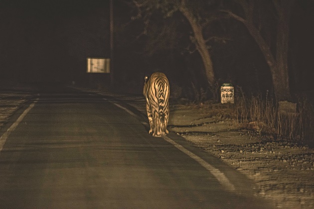
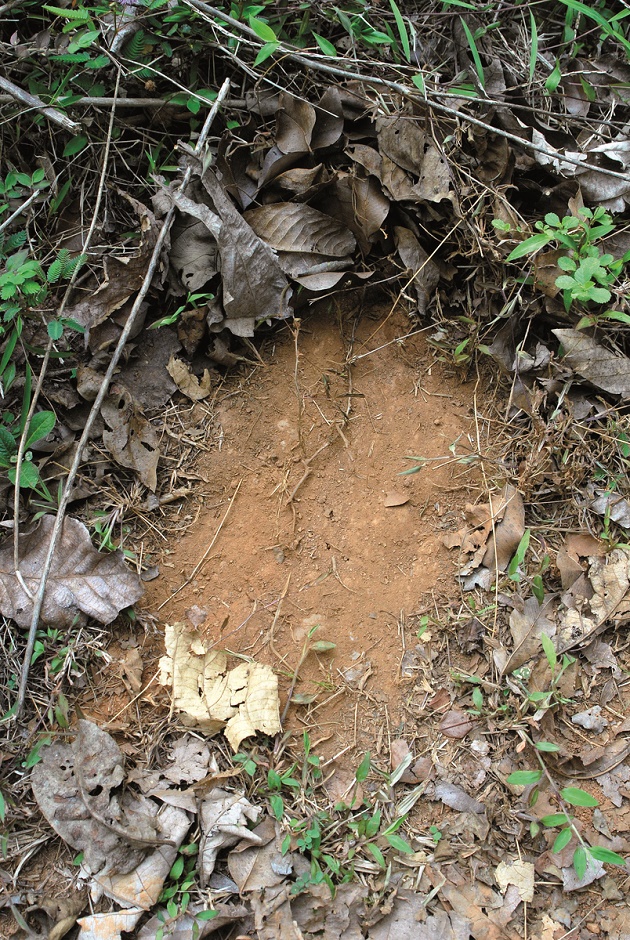 Information on tigers outside Protected Areas is collected through indirect evidences such as scrape marks on the forest floor, rake marks on tree trunks, scats, pugmarks and images from camera traps carefully deployed along known tiger patrolling routes, or on cattle kills. Photo Courtesy: Dr. Anish Andheria
Habitat connectivity must therefore be seen to be critical to the survival of Panthera tigris tigris through a combination of stable corridors such as riparian/riverine forests with minimal human disturbance and well-protected Territorial Forests situated within 50 km. from national parks and sanctuaries. It is equally important that the human population living close to tiger forests know how to and are willing to live in relative peace with tigers and the wild herbivores upon which the carnivores depend. Even if the first two criteria are met, it is never going to be easy to achieve the third. In recent times, a spate of human-wildlife conflicts exemplify the growing hostility of communities towards wildlife, especially towards large herbivores and carnivores.
The culture of communities in the state allowed the survival of large mammals into the 21st century, but to anticipate such a harmonious coexistence in the future would be wrong. The reasons are easy to see… a burgeoning human population, disparity between the rich and poor, adverse hydrological flows in rivers because of forest degradation and, of course, the negative impacts of climate change.
The theory of metapopulations
Tigers are distributed in a patchy mosaic of habitats comprising disjointed Protected Areas including cores that are largely undisturbed, buffers that are relatively more disturbed, other disjointed Protected Areas located a distance away and Territorial Forests both near and far from Protected Areas.
The dynamics of a metapopulation is a function of interactions of tigers within a tiger sub-population (for example interaction of tigers within Kanha) as well as of tigers between different sub-populations (for example between tigers of Kanha and those of Balaghat), which are made possible through corridors. Corridors enhance the ability of individual tigers to move between habitat patches, enabling recolonisation of a patch that has suffered local extinction or aid movement from well-populated patches into patches that have suffered depletion in recent times. In other words, emigration and recolonisation, work in tandem to reduce the probability of extinction of the metapopulation. This is possible only when good quality corridors exist between forest patches.
The Greater Pench Landscape
Consider Pench, M.P. (1,179 sq. km.), and we can see why it is probably the most secure tiger population in central India. The park supports just over 40 adult tigers (less than the desired 100), but it is contiguous with Pench, Maharashtra, (741 sq. km.), which has another 40 adult tigers. This still does not add up to 100 adults, but what tilts the balance in its favour, is the existence of quality corridors connecting the Pench twins with Kanha (2,051 sq. km.) to the northeast, with Navegaon-Nagzira (1,895 sq. km.) in Maharashtra to the east (albeit weakly) and to Satpura (2,133 sq. km.) towards the northwest.
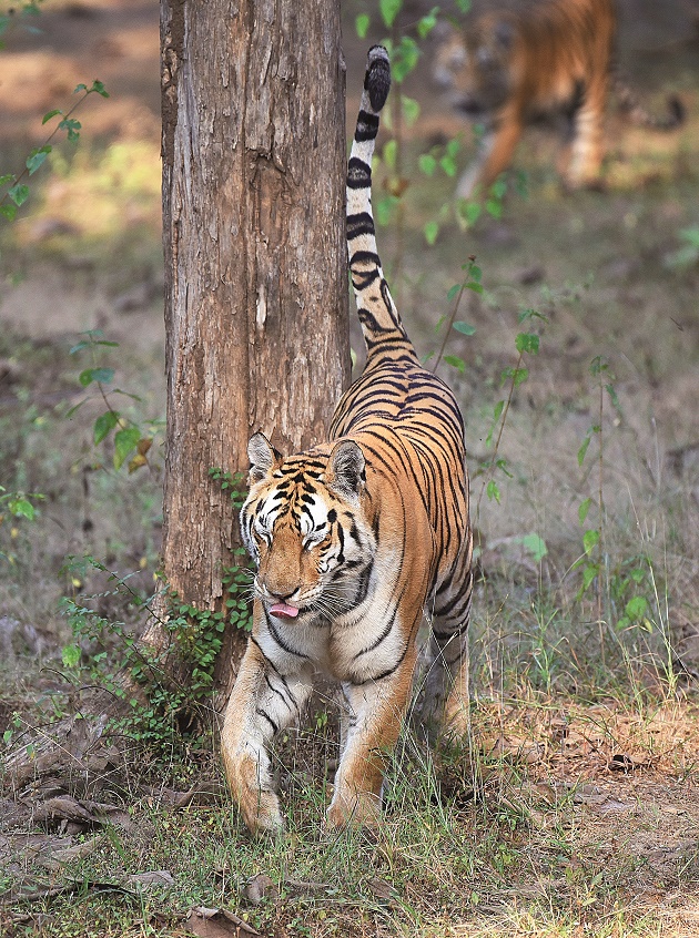 An adult tigress marks her territory by spraying scent-loaded urine, with an odour unique to her, to inform other tigers of her presence. Photo Courtesy: Dr. Anish Andheria
This first-rate connectivity pushes the effective tiger population of the Pench twins (1,920 sq. km.) to well over 100 adult tigers and 20 breeding females, making these parks even more stable than Kanha.
Corridor conundrum
Those in the know understand that the long-term sustenance of a tiger population is not merely dependent on the quality of protection within tiger reserves, but also on healthy corridors and tiger-bearing forests outside. Unfortunately, the term ‘corridor’ conjures up a cloud of confusion amongst scientists, park managers and policy makers, especially as they come from different backgrounds. Some base their classification of corridors on their functional property, that is on whether they allow movement of a target species irrespective of the corridors’ physical attributes. For example, under the cover of darkness, tigers move as easily through agricultural lands as they do through degraded forest and hence even crop fields adjoining forests form an integral part of a functional corridor. Often park managers place a greater emphasis on structural corridors. For example, a forest patch that has a thick forest canopy or a relatively wide strip of land with homogenous tree cover is assumed to favour the movement of the target species and therefore is classified as a structural corridor without any investigation. This lack of clarity has ramifications on the understanding of functions, design and the management of corridors.
Everyone agrees that fragmentation on account of habitat loss is a major threat to biological diversity. In such a scenario, corridors are extremely critical to the survival of biodiversity.
Unfortunately, some researchers, with an incomplete understanding of both tiger ecology and corridor dynamics have resorted to reductionism by focusing on an extremely specific function, and in the process mistakenly define a misguidedly small proportion of the actual available habitat as a ‘corridor’. This gravely threatens the integrity of habitats between tiger reserves through which tigers can and do move.
Wildlife managers must be able to differentiate between structural ‘connectedness’ and functional ‘connectivity’. For instance, linear landscape elements such as a thin strip of plantation or a narrow patch of forest along a stream that appear to physically connect two tiger habitats do not necessarily enhance connectivity for tigers when there are other disturbing land uses in close proximity. Similarly, lack of structural connectedness, that is absence of a forest patch or a stream does not mean tigers will not move from one habitat to another. Radio collaring has shown that tigers move through agricultural fields with ease at night.
 Radio collars and satellite telemetry are important scientific tools that use very high frequency (VHF) electromagnetic radio and satellite signals respectively to detect the signals emitted from specially-designed collars fitted around the tiger’s neck. VHF is used to track animals over short distances of two to three kilometres, while satellite telemetry allows tracking animals remotely across vast landscapes. Photo Courtesy: Dnyanesh Rathod
Another grave error is to treat corridors as mere conduits for movement, not deserving of a high level of protection. Our work at WCT reveals that the Kanha-Pench corridor has a resident breeding population of tigers no different to Protected Areas.
The fact is that corridors can and often do perform multiple functions and their designs are site and species specific. Conservation biologists and forest managers must be guided by the precautionary principle and should disallow any land use patterns that threaten the sanctity of corridors, which, once snapped are next to impossible to repair.
Important tiger conservation units
The simple fact is that without strengthening and protecting the corridors connecting these parks in the long run, it is unlikely that even the most famous parks could sustain tiger populations for too long.
Take the case of the forest connectivity between Kanha and Maharashtra’s Navegaon-Nagzira to the south through the Balaghat Forest Division. This is further connected with the Tadoba-Andhari Tiger Reserve by way of the Territorial Forests of Adyal and the Umred-Paoni-Karhandla Wildlife Sanctuary. Kanha also hooks up with the Achanakmar Tiger Reserve in Chhattisgarh through the Phen Wildlife Sanctuary.
Pench connects with Melghat, thanks to the Mahendri Forest Block, which along with the Warud Forest Block, is then linked with the Talegaon Forest Range, and then on to Bor. I have not just travelled these landscapes, but spent hours looking at satellite imagery to see how the tiger forests of Maharashtra’s Pench are linked with Navegaon-Nagzira to the east through Mogarkasa, Paoni, Landezari and Nakadongari.
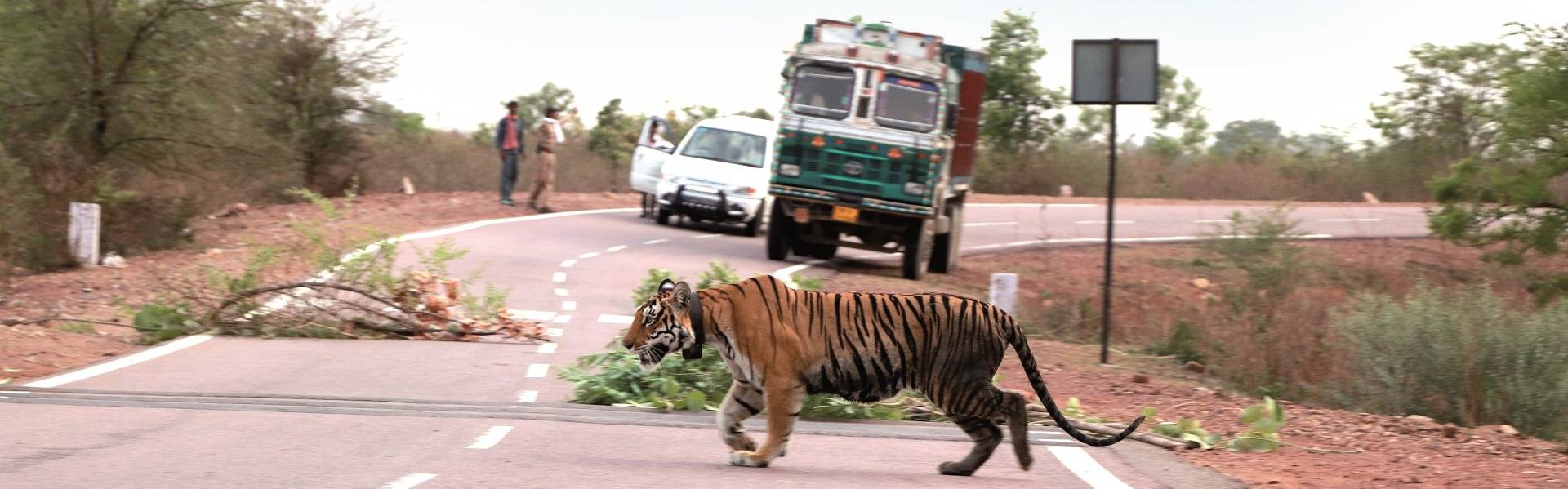
For the tiger, human-delineated boundaries mean nothing, but human intrusions and blockages could mean everything… including death.
Even amateur wildlife protectors, who learn to use Google Earth (it’s bone simple) will see that Kuno-Palpur is definitively connected to Rajasthan’s Ranthambhore Tiger Reserve towards the north-northwest. And the Satpura Tiger Reserve is linked to Maharashtra’s Melghat to the southwest. Similarly, Sanjay-Dubri is contiguous with Guru Ghasidas in Chhattisgarh in the south-southeast direction.
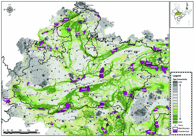 The map shows the actual tiger corridors in varying shades of green as identified using Circuitscape.
Forests are a concurrent subject, but when the penny finally drops and planners understand the umbilicus between forests and rivers, they will see that the corridors underscored by this article have a value far above that of the ‘mere’ saving of a charismatic animal. They are critical to the water security of the Indian subcontinent. And towards this objective, M.P. has a critical role to play in the survival not only of central India, but the peninsula as a whole.
Tigers interrupted
The corridors between Kanha and Pench are robust but are currently damaged by canals, roads and rail track expansions. Others are slowly succumbing to degradation and fragmentation at the hands of human-caused fires, firewood collection, livestock grazing and bush meat hunting by local communities, who are in fact eating into their own sustainability. If we were able to achieve congruence between the Ministries of Surface Transport and the Ministry of Environment, Forest and Climate Change, significant improvement could be achieved in very short order by planning infrastructures right and properly evaluating the natural assets that the Forest Department is mandated to protect.
Impacts and solutions
A recent study by WCT analysed the network of roads, railway lines and canals cutting or threatening to cut corridors in eight states constituting the central Indian landscape. Of the 1,700 proposals awaiting government clearance, 399 are likely to disrupt or disturb tiger corridors. Of these, as many as 96 will cut through functional tiger corridors in M.P.. This is happening primarily because corridors are not defined in a comprehensive manner and planners sitting far from the planned alignments readily draw straight lines, where even minor adjustments might save critical corridors. Translated, this means the best option becomes the least-cost option, even when a vast array of alternate alignments are available.
 As India develops at a rapid pace, more linear infrastructures such as roads, railways and canals are coming up across the length and breadth of the country including in fragile forested ecosystems. Photo Courtesy: Farhan Khan
For M.P., a state for which wildlife tourism is likely to be one of the largest employment and livelihood generators, there is a pressing need to put this information in the hands of planners and in the public domain. In particular, park directors and members of the Madhya Pradesh State Wildlife Board must have access to such information, so realignments are possible even before time and money are spent.
While a lot of focus is lavished on mitigation measures including under and over-passes for the movement of wildlife, we must also recognise that existing alignment need such investments too. For this welcome step to be taken, all concerned must know that the forest itself is an economic infrastructure (think tourism, water harvesting, carbon sequestration) and that destroying one infrastructure to set up another may not be in the best interests of the state. If mitigation becomes an integral part of the thought process of linear infrastructure projects, the cost would be significantly less than such measures taken as an afterthought at the insistence of courts, or public opinion. In any case, budget allocations for mitigation must be factored in before ground is broken to avoid going over budget and to avoid delay in implementation.
Had proper processes been followed and long-term scientific studies carried out, the mitigation cost and delays in completion of National Highway-7, which dissects the vital Kanha-Pench-Navegaon-Nagzira corridor, would have been far lesser. A combination of sound engineering, conservation biology and transparency regarding the alignment of the project before the Detailed Project Report (DPR) stage could have ensured a win-win for both development and ecology.
In the years ahead, there is absolutely no doubt that countries will be forced to lavish most of their national budget on the protection of the ecological foundation upon which all economic foundations are built.
With the technology available to us today, the role of guesswork in national planning has been largely eliminated. The issue is no longer ‘how to save wildlife’ but what advantages accrue from the fabled biodiversity of the Indian subcontinent and why our biodiversity should be saved in the first place.
Today, M.P. has the expertise and the experience to set the best possible example for rest of India in terms of how the quality of our environment can be improved, even as the quality of life of our people is enhanced. Even a casual investigation of buffer zone management around the best of M.P.’s tiger reserves will confirm that given the resources and mandate, the Forest Department is more than capable of threading the needle between protecting our biodiversity and securing the interests of communities living next to our finest biodiversity vaults.
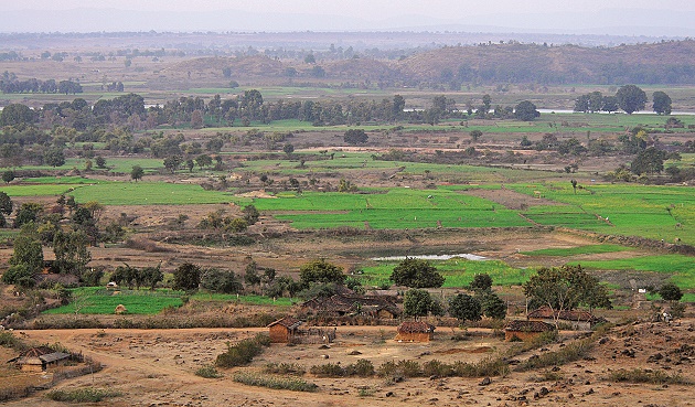 A typical tiger reserve buffer zone comprises riverine habitats interspersed with a mosaic of Reserve Forests, agricultural fields and villages. Photo Courtesy: Dr. Anish Andheria
What remains to be done is to harmonise the mandate of the Forest Department with that of the Tourism Department in a manner as to deliver not only revenue to the state, but also lean season flows of water to the dam reservoirs upon which millions of farmers, industries
and municipalities depend.
Corridor Definitions
The term ‘corridor’ has been used in many ways:
- Distinct habitat, whether or not it aids movement.
- Biogeographic land bridges.
- Series of discrete `stepping stone’ refuges.
- Highway underpasses and tunnels designed for wildlife passage e.g. underpasses constructed on NH-7.
- Strips of land facilitating movement between large habitats e.g. riverine forests (thin forest strips alongside rivers).
Corridor Functions
Corridors are known to perform the following functions:
- Permit colonisation of new sites as and when they become suitable.
- Allow wildlife to move out of sites as they become unsuitable.
- Permit recolonisation of sites that have lost all individuals in the past.
- Allow movement of species between areas needed for different stages of their life cycles.
- Increase overall extent of habitat, especially for species with large home ranges.
- Very wide corridors may support the complete range of community and ecosystem processes, enabling plants and animals to move between large reserves over a period of generations. These are called landscape linkages and are intended to provide regional connectivity eg. Kanha-Pench corridor including the Balaghat Forest Division. This landscape is no different from a Protected Area in terms of biodiversity and breeding success. It supports a healthy population of resident tigers. Cubs born to these tigers eventually disperse to neighbouring tiger reserves and some of them end up becoming dominant residents in those reserves.